MASSIVE GROUNDWATER WITHDRAWAL IN THE VICINITY OF MAJOR SEISMOGENIC FAULTS (SE SPAIN AND CALIFORNIA). A NEGLECTED QUAKE-HAZARD?
Fluids play a major role in controlling pore pressures
and generating effective stresses capable of reactivating faults and inducing seismicity
(Wang and Manga, 2009). Hydroseismicity is receiving increasing attention as it
is now obvious that earthquakes are definitely influenced by water (Wang and
Manga, 2009). Massive extraction of water triggers aquifer compression,
sediment compaction, basin subsidence, centripetal horizontal displacements,
changes in vertical/horizontal-strains, ground-fissuring, fault slippage and/or
seismicity (Wang and Manga, 2009). Many documented examples of substantial
water-extraction triggering ground subsidence and/or deformations occur in
highly populated areas exposed to strong seismic risks (Mexico City, Jakarta,
Teheran, California). Surprisingly, this hydrological geohazard is not
considered in quake forecasts (WGCEP, 2008), in spite of such warnings as those
issued after the 7.6 Mw event devastating India in 2001: “Widespread water withdrawal by pumping might be a factor in the Gujarat
earthquake” (Vu, 2001). Another similar case of induced seismicity is the 2015 M 7.8 Gorkha, Nepal, megaearthquake, which has been linked to massive groundwater depletion beneath the Indo-Gangetic plain, one of the most densely populated regions of the world (Kundu et al., 2015): the gigantic load removed in such a way from the footwall of the Main Himalayan Thrust encouraged the slip of this major low-angle compressional ramp.
We will first describe the 2011 Lorca seism (SE Spain;
5.1 Mw), showing that there was a cause/effect relationship in terms of groundwater-depletion/induced-seismicity
(GDIS). We will then suggest that the renowned seismic-prone Californian realm is
a notorious case where GDIS might be a very serious example of neglected quake
hazard.

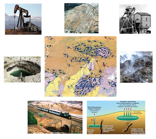
Hydroseismic
hypothesis for SE Spain. A: Map of the Guadalentín Basin (GB) showing the 1996-2001 subsidence rates (González and
Fernández, 2011), the epicenters of the Lorca seismic series (IGN, 2011; USGS,
2011) and the Alhama de Murcia Fault (AMF). Cartoons B and C illustrate this
hypothesis with two evolutive cross-sections of the GB (I-I’ in A): preseimic
(B) and seismic/postseismic (C) stages. 1: maximum subsidence area; 2: vertical
and horizontal strains linked to aquifer compaction; 3: clamping stresses
induced by decreasing pore fluid pressures; 4: effects of vertical unloading by
loss of water: inhibited upward
expansion of lithosphere (a) and increasing differential stresses along the AMF
(b); 5: regional compression; 6: main earthquake; 7: upward readjustment of a
basement horst; 8: cluster of aftershocks.
THE LORCA
SEISM (SE SPAIN)
Using satellite radar interferometry, González and Fernández (2011) find out the highest rates of land subsidence in Europe resulting from massive aquifer-pumping for water irrigation in the Guadalentín basin (GB) in SE Spain (figs. 1A & 2A). Despite the fact that the GB is bounded by the seismogenic Alhama de Murcia Fault (AMF), González and Fernández (2011) do not discuss its tectonic context or the possible influence of groundwater extraction, aquifer forcing and subsidence on seismicity, as done in other active areas undergoing fluid extraction (e.g., Fialko and Simons, 2000).
Coincidentally, a 5.1 Mw earthquake occurred in May 2011 along the reverse/sinistral AMF in the Lorca region studied by González and Fernández (2011), destroying property and lives and making it the deadliest quake in Spain for 50 years (IGN, 2011). Even if this fault belongs to a well-known active tectonic zone (Martínez-Díaz, et. al., 2011), seismicity was anomalous in three respects: 1) the extremely shallow depth of the main shock (1km; USGS, 2011), localized near the base of the GB; 2) the migration of the seismic sequence (foreshock to aftershocks) from the main fault towards the GB; 3) the off-fault location of the cluster of shallow aftershocks concentrating in this basin. A crude spatial correspondence between the maximum basin subsidence (González and Fernández, 2011) and the seismic epicenters (IGN, 2011) is obvious when we superpose the data (fig. 1A).
I was the first scientist to suggest a cause-effect relationship between water extraction and seismicity in the Lorca area: in the press (Doblas, 2011a,b,c July; Fig. 2) and in an International Scientific Conference in our Institution, the IGEO (Doblas, 2011d, November). However, two colleagues of my institution that had access to my theory during this Scientific Conference, "grabbed the basic idea” and published it in Nature Geoscience one year later (González et al., 2012; Avouac, 2012), making no mention to my pioneering hypothesis.


FIGURE 2
Extensive
water-extraction triggering ground deformation and subsidence is documented in highly
populated seismic areas (e.g., Mexico D.F.), constituting a hydrological
geohazard that has been linked to the Gujarat seism devastating India in 2001 (Vu,
2001). Although the mechanism by which fluid extraction induces earthquakes is
still poorly understood (e.g., Yerkes and Castle, 1976; Wang & Manga, 2010),
the hydroseismic model for Lorca suggests a complex interplay between three
processes linked to water extraction: 1) reduction of the pore fluid pressure;
2) compaction of the aquifer; 3) reduction of the vertical load of water. In
any case, the rocks in the Lorca contractional duplex were so close to a
critical state of equilibrium that seismicity is conceivable via relatively
small perturbations.
Reduction
of pore fluid pressure tends to increase the AMF clamping stress, stabilizing it
by increasing the effective normal stress, in what constitutes the classical paradox
of water extraction as a trigger of seismicity (e.g., Holzer, 1979; Segall,
1989; Fialko and Simons, 2000).
However,
the two other processes compensate this effect by decreasing the AMF clamping
stress. Decades of aquifer forcing by fluid extraction might trigger huge differential
compaction rates capable of enhancing seismicity, once strains reach certain critical
values, as described in California by Yerkes and Castle (1976) in terms of extreme
vertical and horizontal displacements (up to 9m). Compaction of underground
reservoirs by fluid extraction also decreases the normal stresses, thus reducing
the effective shear strength on seismogenic planes on the verge of failure (Segall, 1989; Costain, 2008).
The reduction of the vertical load due to the removal of
large masses of groundwater by pumping triggers elastic expansion of the
lithosphere and crustal uplift, thus diminishing surface stresses over large
areas (Holzer, 1979). However, shallow-seated land subsidence by compaction of
unconsolidated alluvial aquifers (as in Lorca; González and Fernández, 2011) tends
to mask surface expressions of the deeper-seated elastic expansion of the
lithosphere (Holzer, 1979)
In conclusion, the hydrological-induced seismicity model
for Lorca might be envisioned as follows (figs. 1B and C): decades of water
extraction progressively compacted and deformed the GB aquifer via large
vertical and horizontal strain changes, decreasing the AMF clamping stresses. Vertical
unloading by the loss of water increased the differential stresses, further destabilizing
the AMF thrust. The tendency for upward rise of the basement (due to vertical
unloading) was inhibited by the NW-directed regional compression. The accumulated
differential stresses finally unclamped the AMF during the main seism, near the
base of the GB (in the vicinity of the water-depleted sector). The aftershocks clustering
below the higher subsidence area might correspond to the upward readjustment of
a buried basement horst activated by the earthquake, allowing some elastic
expansion of the lithosphere.

GDIS
HAZARD IN CALIFORNIA
Three apparently unconnected Californian observations make the GDIS hypothesis even more intriguing on a larger scale (fig. 3b). A) The southern/locked San Andreas Fault segment was the site of the largest earthquake in California in 1857, and presently it still bears the highest probability of a big seism (WGCEP, 2008; Kerr, 2011). In fact, deep tremors and micro-earthquake swarms are scrutinized along the Parkfield/Cholame segment, in case such activity might forewarn a big earthquake (Nadeau and Guilhem, 2009; Shelly et al., 2011; Thomas et al., 2009). B) Significant hydrological-induced variations of the stress field along the southern San Andreas fault have been shown to trigger seasonal variations of the seismicity (Parkfield segment; Christiansen et al., 2007) and extra-loading strains (Salton Sea; Brothers et al., 2011). C) Recent gravity-based satellite findings reveal major groundwater loss by unsustainable agriculture along the Californian Central Valley (bounding the San Andreas Fault), a state-wide environmental crisis widely exposed in the media: “From October 2003 to March 2010, aquifers under the state’s Central Valley were drawn down by 25 million acre-feet, almost enough to fill Lake Mead, the nation’s largest reservoir” (Farmiguetti et al., 2010). The maximum water depletion concentrates in the SW tip of this valley (San Joaquin basin), in close contact with the most seismically-hazardous sector of the southern/locked San Andreas Fault (fig. 3b). If we match up A, B and C, bearing in mind the Lorca case (fig. 3a), we believe the GDIS hypothesis is highly conceivable and should be very seriously considered in southern California by the so-called "Working Group on California Earthquake Probabilities" (fig.3b).
Acknowledgements: I thank Julia de las Doblas for the drawing of the figures.
REFERENCES
-Avouac, J.P., 2012, Human-induced shaking: Nature
Geoscience, v. 5, p. 763-764.
-Brothers, D., Kilb, D., Luttrell, K., Driscoll, N.
& Kent, G., 2011, Loading of the San Andreas fault by flood-induced rupture of
faults beneath the Salton Sea: Nature Geoscience, v. 4, p. 486-492, doi:10.1038/ngeo1184.
-Christiansen, L.B., Hurwitz, S. & Ingebritsen,
S.E., 2007, Annual modulation of seismicity along the San Andreas Fault near
Parkfield, CA: Geophysical Research Letters, v. 34, L04306,
doi:10.1029/2006GL028634.
-Costain, J.K., 2008, Intraplate seismicity,
hydroseismicity, and predictions in hindsight: Seismological Research Notes, v.
79, p. 578-589.
-Doblas, M., 2011: a) https://www.youtube.com/watch?v=J5ArtXJJBhk; b) https://www.youtube.com/watch?v=HaDCqyOiTLM; c) https://www.laopiniondemurcia.es/municipios/2011/07/20/experto-cree-sobreexplotacion-acuiferos-pudo-agravar-seismo/338431.html); d) Tectónica activa en las Placas Caribe e Ibérica. Primera reunion Científica IGEO, 15-16 September, p.9-10. https://eprints.ucm.es/14572/
-Farmighetti et al., 2010, California's troubled waters: Satellite-based findings reveal major
groundwater loss in Central Valley: University of California Center for Hydrologic
Modeling, https://phys.org/news/2009-12-california-satellite-based-reveal-major-groundwater.html
-Fialko, Y., and Simons, M., 2000, Deformation and
seismicity in the Coso geothermal area, Inyo County, California: Observations
and modeling using satellite radar interferometry: Journal of Geophysical
Research, v. 105, p. 21,781-21,793.
-González, P.J., and Fernández, J., 2011,
Drought-driven transient aquifer compaction imaged using multitemporal
satellite radar interferometry: Geology, v. 39, p. 551-554.
-González, P.J., Tiampo, K.F., Palano, M., Cannavó, F and Fernández, J., 2012. The 2011 Lorca earthquake slip distribution controlled by groundwater crustal unloading. Nature Geoscience, V. 5, p. 821-825.
-Holzer, T.L., 1979, Elastic expansion of the
lithosphere caused by groundwater depletion: Journal of Geophysical Research,
v. 84, p. 4689-4698.
-Instituto Geográfico Nacional
(IGN), 2011, Serie terremoto NE Lorca (Murcia), 11 mayo 2011. http://www.ign.es/ign/resources/sismologia/Lorca.pdf.
-Kerr, R.A., 2011, Seismic Crystal Ball Proving Mostly Cloudy Around the
World: Science, v. 332, p. 912-913.
-Kundu, B., et al, 2015. Influence of anthropogenic groundwater unloading in Indo-Gangetic plains on the 25 April Mw 7.8 Gorkha, Nepal, earthquake. Geophysical Research Letters, v. 42, p. 10.607-10.613.
-Martínez-Díaz, J.J., and 8
others, 2011, Informe geológico preliminar del terremoto de Lorca del 11 de
Mayo del año 2011, 5.1 Mw. Instituto Geológico y Minero de España, Madrid, 47
pp.
-Nadeau, R.M. & Guilhem, A., 2009, Nonvolcanic
tremor evolution and the San Simeon and Parkfield earthquakes, California: Science,
v. 325, p. 191-193, doi:10.1126/science.1174155.
-Segall, P., 1989, Earthquakes triggered by fluid
extraction: Geology, v.17, p. 942-946.
-Shelly, D.R., Peng, Z., Hill, D.P. & Aiken, C.,
2011, Triggered creep as a possible mechanism for delayed dynamic triggering of
tremor and earthquakes: Nature Geoscience,
v. 4, p. 384-388, doi:10.1038/ngeo1141.
-Thomas, A.M., Nadeau, R.M. & Bürgmann, R., 2009,
Tremor-tide correlations and near-lithostatic pore pressure on the deep San
Andreas fault: Nature, v. 462, p. 1048-1051.
-USGS, 2011, http://earthquake.usgs.gov/earthquakes/eqinthenews/2011/usc0003c5s/.
-Vu, P., 2001,
Lamont scientists study India earthquake up close: Columbia University Record,
v.26, p. 19.
-Wang, C.Y., and Manga, M., 2010, Earthquakes
influenced by water: Lecture Notes in
Earth Sciences, v.114, p. 125-139.
-WGCEP (Working Group on California Earthquake
Probabilities), 2008, http://www.wgcep.org.
-Yerkes, R.F., and Castle, R.O., 1976, Seismicity and
faulting attributable to fluid extraction: Engineering Geology, v. 10, p.
151-167.


Comentarios
Publicar un comentario